By Dr Kyaw
(Meteorology School)
Abstract
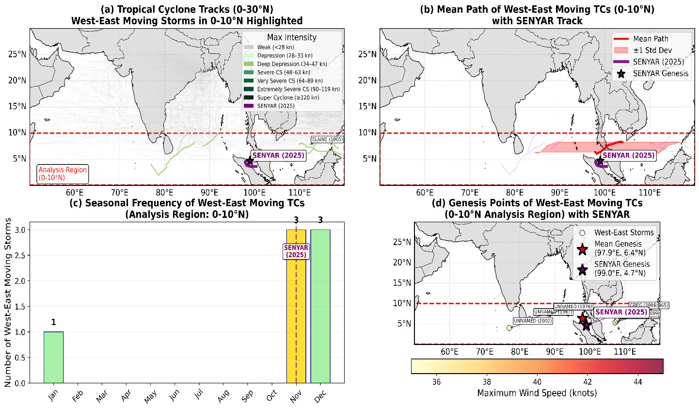
This study analyzes the unusual westward-to-eastward movement of Tropical Cyclone "Senya", which occurred near the Strait of Malacca in November 2025 and caused significant flooding in Malaysia and Southern Thailand. The cyclone's track is compared with historical data (1949-2025) of storms moving west-to-east between 0-10°N latitude. Such eastward-moving cyclones are extremely rare in this region, representing only 1.9 per cent of all recorded storms in the period, making "Senya" a remarkable meteorological event.
1. Introduction
Tropical cyclones typically move from east to west. However, some storms occasionally move in the opposite direction. This paper examines the characteristics of these rare west-to-east moving cyclones in the 0-10°N latitude belt, focusing on the Strait of Malacca. It provides a comparative analysis of Cyclone "Senya," including its track, impacts, and the physical reasons behind its unusual movement.
2. Overview of Cyclone "Senya"
Cyclone "Senya" (04B) formed around 25 November 2025, intensifying from a strong monsoon depression (95B).
• Genesis: It originated near 3.6°N, 99.9°E, in the southern Bay of Bengal near the Strait of Malacca. "Senya" is one of the closest recorded cyclones to the equator in the Northern Hemisphere, and only the second such system to form in the Strait of Malacca since Tropical Cyclone Vamei in 2001.
• Track: The storm initially moved eastward, making landfall on the northwestern coast of Sumatra, Indonesia. It then recurved back over the Strait of Malacca, weakening to a "Deep Depression."
• Impacts: "Senya" caused torrential rain, strong winds, widespread flooding, and landslides. This led to significant casualties and displacement in Indonesia (Sumatra and Aceh), Malaysia (including Kuala Lumpur and western/central regions), and Southern Thailand.
3. Comparison of "Senya" with Historical Data
Historical data show that the average genesis point for west-to-east moving cyclones in the 0-10°N zone is near 6.4°N, 97.9°E, close to the sea west of the Malay Peninsula. "Senya's" origin at 3.6°N, 99.9°E was further south, consistent with its rare formation at a very low latitude near the equator. Its subsequent eastward movement also aligns with the average track of historical eastward-moving cyclones.
Seasonally, 57.1 per cent of these rare storms occur in winter (December-February) and 42.9 per cent in the autumn (September-November). "Senya's" formation in November fits this pattern.
Historically, 57.1 per cent of these storms were at "Deep Depression" intensity (34-47 knots). Although "Senya" also weakened to this intensity, it was still reported as one of the most severe storms on record for Malaysia. This indicates that a storm's impact is determined not just by its official category, but also by its rainfall and the population density of the affected area.
4. Physical Reasons for the West-to-East Movement
Typically, cyclones move westward due to steering by easterly winds and Rossby waves. The unusual eastward movement of "Senya" can be attributed to several factors:
1. Weak Steering Flow: Near the equator, the Coriolis force is weak, and upper-level winds that steer storms can be weak. This allows a storm to be influenced more by local pressure systems, leading to an irregular track.
2. Influence of Nearby Pressure Systems: The location of nearby high- or low-pressure systems can push a storm eastward. For example, a strong high-pressure system to the north of "Senya" (over Tibet) may have steered it along its southern flank's easterly flow.
3. Internal Storm Dynamics: A cyclone's movement is also influenced by its internal vorticity and warm core structure. Near the equator, these dynamics can contribute to atypical motion.
4. Topography: The topography of the Malay Peninsula and Sumatra can deflect wind flow, slightly altering a storm's path. "Senya's" recurvature back toward the Strait after hitting Sumatra demonstrates this effect.
5. Conclusion
Tropical Cyclone "Senya" was a rare west-to-east moving cyclone in the Malaysia region. Its atypical track was likely caused by weak steering flows, the influence of nearby pressure systems, and local topography. With climate change, such rare storms may become more frequent. Therefore, it is crucial for residents to heed storm warnings and take necessary precautions. Continuous monitoring of cyclone tracks and intensity is essential. Enhanced cyclone monitoring systems are also needed in equatorial regions in the face of changing climate patterns.
Data Source:
International Best Track Archive for Climate Stewardship (IBTrACS) project. (2023). ibtracs.ACTIVE.list.v04r01.csv [Data set]. NOAA National Centres for Environmental Information. https://www.ncei. noaa.gov/products/international-best-track-archive
Data Citation:
Knapp, K R, Kruk, M C, Levinson, D H, Diamond, H J, & Neumann, C J (2010). The International Best Track Archive for Climate Stewardship (IBTrACS). Bulletin of the American Meteorological Society, 91(3), 363–376. https://doi. org/10.1175/2009BAMS2755.1