Than Htun (Myanmar Geosciences Society)
Since 2017 Myanmar Geosciences Society has been striving to establish National and Global Geoparks in Myanmar. There are about 10 potential areas, which are mainly based on Conservation areas of Forest Department, for upgrading Geopark. Mout Popa National Geopark is now underway. Reviewing the significant information for Monywa Twintaung Aspiring Geopark has been completed and assessment for the remaining potential Geoparks are being carried out.
Geoparks are single, unified geographical areas where sites and landscapes of international geological significance are managed with a holistic concept of protection, education and sustainable development. A Global Geopark uses its geological heritage, in connection with all other aspects of the area’s natural and cultural heritage, to enhance awareness and understanding of key issues facing society, such as using our Earth’s resources sustainably, mitigating the effects of climate change and reducing the impact of natural disasters. By raising awareness of the importance of the area’s geological heritage in history and society today, Global Geoparks give local people a sense of pride in their region and strengthen their identification with the area. The creation of innovative local enterprises, new jobs and high quality training courses is stimulated as new sources of revenue are generated through geotourism, while the geological resources of the area are protected.
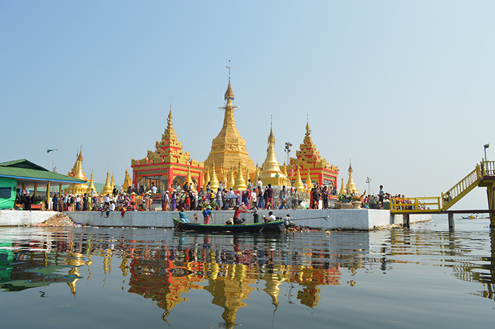
Indawgyi Lake Geopark
Kachin State is the northernmost state of Myanmar. It is bordered by China to the north ( Tibet ) and east (Yunnan), Shan State to the south; and Sagaing Region and India to the west. It lies between north latitude 23° 27′ and 28° 25′ longitude 96° 0′ and 98° 44′. The area of Kachin State is 89,041 km2 (34,379 sq mi). The capital of the state is Myitkyina. Other significant towns include Bhamo, Mohnyin, Hopin and Putao.
The magnificent Indawgyi Lake in Mohnyin Township, Kachin State, is the third largest freshwater lake in Southeast Asia and the biggest natural lake in Myanmar. It is highly predominated with significant natural, biological and geological heritages. Indawgyi Lake is unique and rich in biodiversity, beautiful landscape and sceneries, traditional culture and historic religious sites and various mineral resources. It lies between 25°5′N and 25°20′North latitude and 96°18′ and 96°25′East longitude, and is a fine stretch of water measuring about 16 miles by 7 miles at its widest part. The Indawgyi Lake Wildlife Sanctuary enjoys about 546 feet above the sea level.
History
Traditional Kachin society was based on shifting hill agriculture. According to “The Political Systems of Highland Burma: A Study of Kachin Social Structure”, written by E. R. Leach, Kachin was not a linguistic category. Political authority was based on chieftains who depended on support from immediate kinsmen. Considerable attention has been given by anthropologists of the Kachin custom of maternal cousin marriage, wherein it is permissible for a man to marry his mother’s brother’s daughter, but not with the father’s sister’s daughter. In pre-colonial times, the Kachin were animist. The vast mountainous hinterlands are predominantly Kachin, whereas the more densely populated railway corridor and southern valleys are mostly Shan and Barmar. Before the British rule, roughly 75% of all Kachin jadeite ended up in China, where it was prized much more highly than the local Chinese nephrite. Kachin troops formerly formed a significant part of the Burmese army. With the unilateral abrogation of the Union of Burma constitution by the General Ne Win regime in 1962, Kachin forces withdrew and formed the Kachin Independence Army (KIA) under the Kachin Independence Organization (KIO).
Accessibility
Kachin State is served by the three airports Bhamo Airport, Myitkyina Airport and Putao Airport. There is a railroad between Myitkyina and Mandalay via Sagaing. The train will take 21–30 hours from Mandalay to Myitkyina. Indawgyi Lake can be reached by train from Myitkyina via Hopin and it will take about 5 hours for 107 miles. Again, from Hopin to Lonton Village at Indawgyi Lake by private taxi or by motorbike and it will take 2 hours for 27 miles. The daily train and bus services are available from Yangon or Mandalay to Indawgyi Lake via Hopin the nearest town. Lonton has been upgraded as a new township of Mohnyin District recently.
Inhabitant
The majority of the state’s inhabitants are ethnic Kachin. The Kachin group has six tribes or subdivisions: Jinghpaw, Lisu, Rawang, Lachid, Zaiwa and Lhaovo. The word “Jinghpo Wunpong,” which means “Strong and United Human Beings”, also represents the six Kachin tribes. The region is also home to a number of Shan and a small number of Tibetans. There are 11 village tracts and 33 villages around Indawgyi Lake. The major ethnic groups living in the area are Shan and Kachin, who are mainly are farmers.
Population, religion and languish
According to the 2014 Myanmar Census the population of Kachin State is about 1,689, 441. Christianity is one of the main religion for Kachin people in Kachin State. Buddhism is the major religion among Burmese and Shan in Kachin State. The Jingpho language was the traditional language of the area and the Barmar people were a minority in Kachin State before the independence of Burma from the British, but after 1948, groups of Burmese came to Kachin State to settle down so that offices could be run with the Burmese language. Some Kachin tribes speak and write their own language: the Zaiwa, the Rawang, and the Lisu, who speak both the Lisu language and the Lipo language.
Physiography
Kachin State has Myanmar’s highest mountain, Hkakabo Razi (5,889 metres (19,321 ft)), forming the southern tip of the Himalayas, and the largest inland lake, Indawgyi Lake. Kachin State is famous for its high quality jadeite deposits which extended to Mawlu and Maw Han to the south and Hkamti district to the west. There are many types of lakes and they are classified according to their mode of origin. The principal types are tectonic, glacial, volcanic, river-formed and solution lakes.Tectonic lakes are formed by differential movements of the earth’s crust.
They generally have elongated form, steep sides and great depths. The Dead Sea is a famous tectonic lake and Indawgyi, Myanmar’s largest lake is another good example (Dr. Nyi Nyi, 1964). The Indawgyi Lake occupies a depression hemmed by low ranges of thickly hills on the south, west and east, and has an outlet on the north by the Indaw river, a tributary of NamKawng or Mogaung River. Other streams that flow into it are the Nam Sanda, the Nampade, the Nampaungshin, the Namyang, the Nam Mawn, the Nam-ma, the Long Jum, the Nammawkkam and the Moso. According to the tradition the lake was formed by an earthquake and submerged a Shan town. It is most probably of tectonic origin (Chhibber,1934).
Economy
The economy of Kachin State is predominantly agricultural. The main products include rice, teak, sugar cane, opium. Mineral products include gold and jade. Hpakan is a well known place for its jade mines. Over 600 tons of jade stones were exploited from Lone-Khin area in Hpakan Township in Kachine State. Most of the jade stones extracted in Myanmar, 25,795 tons in 2009–10 and 32,921 tons in 2008–09, are from Kachin State. The largest jade stone in the world, 3000 tons, 21 metres long, 4.8 metres wide and 10.5 metres high was found in Hpakan in 2000. There occurred frequently mine accidents and pollution in jade mine area.
Geology of Indawgyi Lake and surrounding area
Due to various reason no detailed geology around Indawgyi Lake has been done as yet but some potential areas for economic mineral deposits were investigated by Department of Geological Survey and Mineral Exploration, foreign joint venture companies and various local Universities. Indawgyi Lake lies about 70km south-southeast of the famous Hpakant jadeite deposits. Gabbros and occurrences of Platinum Group Elements in placers were known from southwest of the lake prior to the first geological surveys in the area in 1959 (A.H.G. Mitchell, 2018). Beginning in 19191, photogeological mapping was carried out by DGSE in the Nansakyin-Ngagyan area covering about 320sq.km.
Within this area the DGSE exploration was later concentrated within an 80sq,km block in which gabbro is separated from variably serpentinized peridorite to the west by a 2-km-wide northeast-trending belt of schists, with the wide alluvial valley of the Namsang River lying to the west of the serpentinite. Within the 80sq.km block a 4sq.km area in gabbro and schist northwest of Ngagyan Peak was subjected to a more detailed exploration for PGEs. Metamorphic rocks in this area are described as chlorite schists, epidote-actinolite schists, and mica schist with minor gneiss, intruded by gabbro dykes. Diabase dykes intrude both the schist and gabbro. In the late 1990s Soe Thura Tun carried out geological mapping over a 200sq.km area centered on Lagyan (Ngagyan) Peak 15km west of Indawgyi Lake and within the central and eastern part of the 320sq.km Nansakyin-Ngagyan area. During 1996-1998 Leeward Tiger Company from Canada which is Joint Venture exploration programme with DGSE had done PGEs prospecting and exploration in the m,above DGSE area.
Metamorphic rocks are exposed at north of Maing Pok village and western part of the area and composed of schist, gneiss and phyllite. These rocks seem to be the oldest and Mesozoic in age. Igneous rocks of the area is related to those of Taung Thone Lone area and mainly course and medium grained igneous rocks. The microdiorites are observed west of upper Namyin stream west of Mong Pok Village. Due to its hardness it was formed as a mountain range. Dark grey diorite are occurred around Nam Yin Hka stream and consists of coarse grained olivine and pyroxene. Gabbros could be observed between Maing Pok and Nam Tin Hka stream and west of Lonton and Nammilaung Villages. Gabbros are coarse grained and rich in ferromagnesium minerals. Perridotites are scattered in the area west of Maing Pok Village. The small outcrops of granite occur southwest of Nammilaung Village. Vesicular basalts are observed in the gravel west of Maing Naung Village. Wabochaung sandstone formation exposed in the surrounding areas of Maing Naung and Nam Mon Villages. Most of sandstones are massive type deposits and a few are with bedded character. The age of Wabochaung sandstones are regarded as Tertiary in age.
(To be continued)