16 March
By Than Htun ( Myanmar Geosciences Society)
Nowadays all nations in the world are striving to transform their country by UN Agenda 2030 known as 17 Global Goals for Sustainable Development. The UNESCO Global Geoparks are successfully contributing the sustainable development goals in Asia Pacific and Europe.
UNESCO Global Geoparks are single, unified geographical areas where sites and landscapes of international geological significance are managed with a holistic concepts of protection, education and sustainable development.
Sagaing Region covers 93527 sq. km which is the largest region in Myanmar. The region posses natural resources, biodiversity and fertile soil. The single and the best quality jade, gold, copper deposits, industrial raw materials, shallow petroleum reserves, teak and other hard woods, agricultural products such as rice, wheat, sesame, peanut, cotton, tobacco, geologically significant extinct volcanos, maar lakes, well known Stone Age or Neolithic and Bronze cultural heritages, Religious and Archaeological sites are situated in Sagaing Region.
The Sagaing Region lies at a vital place and is bordering India, Nagaland, Manipura, Kachin State, Shan State, Mandalay Region and Magwe Region. The estimated urban population is more than one million and rural population is five millions in the Region.
According to the chronicle of Myanmar History since 1278 at which Bagan dynasty had ended the North Eastern part of Myanmar was controlled by Sagaing Dynasty from 1315 to 1364, by King of Ava from 1364 to 1555, by King Taungoo from 1555 to 1752, before annexation by British in 1885 Konbaung Dynasty ruled the region from 1752 to 1885.
Just after Independence in 1948 the government designated as Sagaing Division. In the Sagaing Region Sagaing District, Shwebo District, Monywa District, Kathar District, Kalay District, Tamu District, Mawlike District and Hkanti District are included. Monywa which the Chief Minister’s office is located is situated at the eastern bank of Chindwin River in Central Myanmar and 136 kilometre away north west of Mandalay. Monywa can be reached by car, by train, by boat and by air from various places in Myanmar.
Geology of Monywa Twintaung area
The geology of Lower Chindwin area had been studied by geologists since pre-war days. Professor A. Boxtorf in 1903, Dr. P. Katerborn in 1924, Dr. R. D. Oldham 1906, E.S. Pinfald, A.E. Day, L.D. Stamp, H; L; Chhibber, Dr. C.T. Barller, Conard Buri and Dr, Hans Huber studied geology in the area during 1921 and 1934. From 1973 to 1974 joint programme with Columbo plan and MMDC studied in detail in Twintaung and surrounding areas. In 1970 an author from Daily News paper wrote an article that due to the volcanoes at Monywa Twintaung area are lying on a straight line he postulated that these volcanoes are formed by the jumping of fallen meteorite on earth. The geologists who know volcanology and volcanism clarified that those are intruded and extruded features of the earth surface.
In 2010 Ali Akabar Khan @ U Khin Maung Htwe from Mandalay University studied the area for his PhD degree and his doctoral dissertation is “Geological and Pertrological Significance of the Volcanic Rocks Exposed in Twintaung-Silaung Area, Monywa District”. Twintaung area is situated on the Central Volcanic Belt of Myanmar and 50 kilometer from North of Mt. Popa. The rocks are of Tertiary in age except the igneous rocks of Salingyi area (Ali A Khan,2010). Eocene rocks are exposed in western part and Miocene clays and sandstones of Irrawaddy Formation, Mio-Pliocene in age, are exposed in the east. The rhyolite, dacites and andesites and copper mineralization are found at Sabe Taung, Lapadaung Taung and Kyesin Taung. The area is mainly covered by volcanic lava, volcanic rocks, Irrawaddy sandstones, granite, diorite, ultramafic rocks and gneiss.
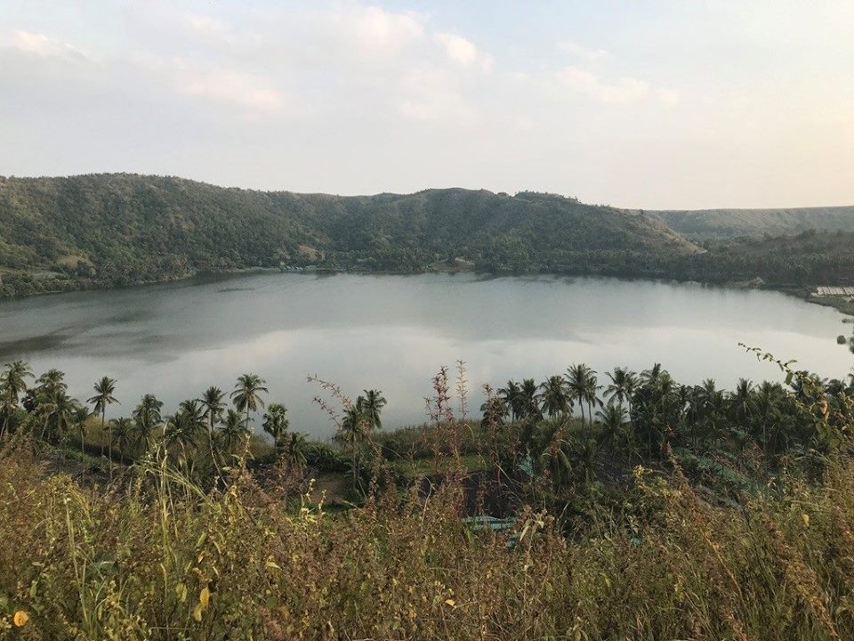
The extinct volcanoes of Lashe, Twinma and Taungbyauk are situated in Kani Township in the west bank of Chindwin River and Twintaung and Nyaunggan volcanoes are situated in the east of Chindwin River. All craters are cone shape and East Twintaung and Taungbyauk crater are phreatomagmatic cones (maars) and the others are cinder cones. The craters are not so high in the flat land but the view from the craters are so beautiful and tephra with thin layers are also valuable for geology and attracted to researchers who are interested in volcanoes and volcanism.
The younger volcanic rocks are deposited after Irrawaddy Formation and age dating by K and Ar on basalt shows 0.44+ or – 0.12 millions years. The older tuff and Irrewaddy Formations are the same age.
Tertiary Maar Lakes
A maar is a shallow volcanic crater with steep sides that is surrounded by tephra deposits. The tephra deposits are thickest near the crater and decrease with distance from the crater. A maar is formed by one or more underground explosions that occur when hot magma comes into contact with shallow ground water to produce a violent steam explosion. These explosions crush the overlying rocks and launch them into the air along with steam, water, ash and magmatic material. The materials usually travel straight up into the air and fall back to Earth to form the tephra deposits that surround the crater. If the tephra lithifies, it will become an igneous rock known as tuff. After the eruption, an inflow of groundwater often turns the crater into a shallow lake. The elevation and water depth of the maar lakes in this region is about tens in meters. The eruption is not only once but also again and again, sometimes, it may take many days.
Spirulina
Spirulina are discovered by Belgium scientist as blue-green algae that is high in nutrients and considered one of the nature’s greatest Superfoods in 1967. In 1984 Dr Min Thein, lecturer from Mawlamyne University studied the spirulina at Twintaung crater in Budalin Township, Sagaing Division and production started in 1987-1988. The maximum production of spirulina in 1999-2000 was over 160 metric ton. In the year 2011-2012 the production declined to 20 metric ton and after 2013-2014 the production of spirulina decreased less than 10 metric ton.
Regarding the decline of production of the spirulina, the generous gift from mother earth Dr Min Thein frequently discussed with the geologists from Myanmar Geosciences Society to search for the reasons why the production had been declined. Although the professionals are producing with sustainable development they could not find the causes of unexpected failure yet. It would be the lesson how the environment and ecology are related each other and importance of collaborative effort by professionals. The establishment of Geoparks could be avoided such problems by collaborative study of environment, educating, conservation and sustainable development practices.
Despite the declination of production of spirulina the beauty of maar lake, tephra sections along the road sides, green environment are attractable to local and foreign guests, researchers and University students. This is the time to make research in Twintaung area on geology, zoology, palaeontology, microbiology, agriculture, biodiversity etc. to develop various arts and sciences. The geotourism will become developed in Sagaing Region and the conservation for environment and ecology is a significant activity. We congratulate the documentary of Channel K in February 2019 in which Chief Minister of Sagaing Region presented about 6 tourist sites in Sagaing Region.
Anythian Culture
The artefacts of famous Anyanthian Culture, Neolithic culture, were found in this area. The axe and tools made up of flint and petrified wood are found in the dry zone of Irrawaddy Valley of Upper Myanmar. In 1894 Dr. F.
Noetling announced that he had found human artifacts in situ in an Upper Miocene or Lower Pliocene horizon at Yenangyaung, Upper Burma.’ Whereas none of the subsequent investigators of this locality challenged the human origin of the specimens, several competent geologists and archaeologists pointed out that identical artifacts occurred in abundance on the surface of the plain some 100 feet above Noetling’s alleged implementiferous stratum. This latter observation was confirmed by various members of the Joint American Southeast Asiatic Expedition during the 1937-1938 season’s field-work; in fact definite evidence was obtained proving that the material in question is Post- Pleistocene in age and that it belongs to a Neolithic culture. The first Palaeolithic tools from Burma were discovered by Mr. T. 0. Morris of the Geological Survey of India during the early 1930’s. Subsequent work in that country by the Joint American Southeast Asiatic Expedition for Early Man has led to the recognition of a new Lower Palaeolithic culture-the Anyathian- which is devoid of hand-axes. There are at least 14 Anyanthian Cultural sites in Myanmar so far.
Pho Win Taung and Shwe Ba Taung
The standard of stone curving, parietal, sculpture and religious of ancient Myanmar can be observed at Pho Win Taung and Shwe Ba Taung which 25 kilometer west of Monywa at Yinmabin Township in Sagaing Region. According to the Myanmar legends, the Pho Win Taung caves were once the abode of an alchemist who possessed supernatural powers. The name of the alchemist who lived in these caves was U Pho Win and in honour of him the mountain and caves were named Pho Win Taung. U Pho Win was so powerful that he could fly, survive under the water, cure manifold illnesses, turns base metals into gold. He practised Samahta Meditation to attain Siddhi or the ultimate state of renunciation.
There are more than 900 man-made caves and about 446,444 Buddha image and ancient painting on the inner wall of the caves. Most of the paintings are based on Jataka story of Buddha but due to overlap painting on the same place therefore the age of painting is impossible to estimate. It was believed that the King Bandawa donated the caves and building in 849. In 17th and 18th century the wealthy people donated Buddha Images, bells and lion images which were made up of Bronze. The bronze artefacts are, due to lack of conservation, deteriorating and the source of copper metal were considered to be carried from nearby Kyeesin Taung, Sabe Taung and Lapadaung Taung mines. If it is so we can imagine how the human beings and planet earth related each other since prehistoric days. These are the most significance value for establishing the UNESCO global Geopark in this area.
Shwe Ba Taung is located on the west bank of Chindwin river just beyond the Pho Win Taung. Tremendous amount of caves and temples are curved out from the surrounding volcanic rocks and filled with ancient Buddha Images. The 13th Century mural paintings are on the wall of the caves and proud of showing the rank of ancient arts of Myanmar.
Nyaunggan Bronze Age Culture
The Nyaunggan Maar lake and bronze age artefacts from ancient cemetery on the rim of the crater is invaluable Archaeological Heritage of Myanmar. The Nyaunggan crater has lack of water before 7 years ago but the crater has received some amount of water knowing without any reason.
The local farmer U Chit Hlaing discovered some artefacts when he was ploughing his farm in 1997 and he reported to Tanpawaddy U Win Maung via local carpenter U Htwa. As U Win Maung is expert in archaeology he excavated the first place at Nyaunggan grave yard and discovered earthen pots, bronze artefacts and some ceremonial stone rings. In 1998-99 the Department of Archaeology excavated Nyaunggan first time that a cemetery yielding bronze artefacts had been systematically explored. The bronze weapons and ceremonial rings in mortuary contexts gave some evidence of ranking but there has not been full analysis of these in relation to pottery, the most abundant grave good. The archaeologists pointed out that the Stone Age and Bronze Age are overlapping in Myanmar and Bronze Age would be BC1500 and Iron Age would be BC 500 respectively.
The ancient elephant fossils
The villagers from Pauk Tike reported Myanmar Geosciences Geopark Development Committee in November 2018 that they have found the teeth and jaw fossils of giant animal near the village and request to identify the kind of animal. Some petrified woods are also occurred along the creeks and on the hill top. During first week of March in 2019, Dr Yupa Thasod from Chaingmai University identified the teeth and jaw fossils and pointed out that those are fossil remains of four-tusk ancient elephant “Steglophodon”, approximately 1.5 to 15 million years in age. The petrified wood and vertebrate fossils occurred at Pauk Tike in Yinmabin Township and those of Mount Popa in Kyaukpadaung Township are formed in the same environment which is sandstone and gravel beds of Irrawaddy Formation.
Therefore, fossil wood and vertebrate fossil bearing Irrawaddy Formation is spreading both side of Ayeyawaddy River from Katha in the north to Yangon in the south.
The above mentioned Monywa Twintaung area of Sagaing Region occupied invaluable natural heritage, geoheritage, cultural and archaeological heritage and in addition the local and foreign tourists are significantly increasing these days. Therefore, we are confident that this is the time to establish National Geopark and UNESCO Global Geopark by collaborative effort in education, conservation and sustainable development in Monywa Twintaung area.