By THAN HTUN (GEOSCIENCE MYANMAR)
LATE PLIOCENE AND PLEISTOCENE IGNEOUS ACTIVITY.
Professor HL Chhibber (1934) provided a detailed account of igneous activities at Mount Popa, along with a comprehensive report on the igneous occurrences in the lower Chindwin region, presented in Chapter XXIX of The Geology of Burma. Due to space limitations, only the most significant points are summarized below.
In Burma, the later stages of the Pliocene and the whole of the Pleistocene period were very important as regards manifestations of igneous activity, which were certainly rife at nine centres at least, excluding the Teng-Yueh area in Yunnan. During these eruptions, voluminous floods of lava and ashes were poured forth, and the periods of igneous activity were marked by intervals of quiescence and by repeated renewals of volcanic energy.
The different centres comprise those of the Jade Mines area, Myitkyina district, the Lower Chindwin region, Shinmadaung, Mount Popa area, Kawet area, Shwebo and Mandalay districts, Thaton district, Loi Han Hun volcano in the Northern Shan States and Medaw Island in the Mergui Archipelago. The Pegu Yoma’s dolerites were probably intruded at about the same time. Some old volcanoes in the neighbourhood of Teng-Yueh in Yunnan and those of Barren Island and Narcondam were also active simultaneously. At some of the centres groups of volcanoes are to be seen at the present day, e.g., in the Lower Chindwin region alone there are seven to eight craters, besides several flows of lava, ash-beds, etc. This article will briefly discuss the igneous occurrences of the Lower Chindwin Region.
Igneous Occurrences of the Lower Chindwin Region.
The igneous occurrences described below occur on both banks of the River Chindwin in an area roughly between Lat 21° 31’and 22° 30’North and Long 94°45’and 95° 30’East. R D Oldham was the first to give a complete account of the explosive craters of this region. Later on, roughly 4,000 square miles of this area were surveyed geologically by Messrs Pinfold and A E Day. The central part of the area, both to the east and west of Monywa, was mapped independently by L D Stamp in the cold season of 1921-22. The igneous rocks have been examined in the laboratory of the Department of Geology of University College, University of Rangoon, by L Dudley Stamp and the present writer. The results of the fieldwork by Messrs Pinfold and Day and the laboratory work by Dr Stamp and the author were published in the Transactions of the Mining and Geological Institute of India, vol xxi, 1927, pp 145-225. Lately, Professor Conrad Burri and Herr Hans Huber have published a description of the petrology of some of the rocks from this region.
The igneous rocks form a well-defined series, with certain characteristics which indicate that they belong to the Pacific suite. The volcanic rocks range from rhyolites, in which secondary changes are most marked, through andesites to basalts, among which the most characteristic and interesting members are very basic olivine-basalts (picrite-basalts) approaching basanites but apparently without feldspathoids. The hypabyssal rocks include both acid and intermediate types. Some of the basic basalts as well as many of the acid ones, should perhaps be classed rather as hypabyssal rocks, occurring, as they do, as plugs or necks. Some of the hypabyssal rocks are coarse-grained and might be classed as plutonic rocks, but it is the ejected blocks from the explosion craters that afford the most interesting examples of plutonic development- more especially a remarkable series of ultrabasic types.
Perhaps the most characteristic rocks of the whole series are the picrite basalts, so it will be convenient to arrange the descriptions, starting with the basic types of passing to the intermediate and acid types.
The following rocks are present in the collections: —
Volcanic Rocks.
I. Picrite-basalts- (a) Kuaukka Daung, Hill 779,
Natyindaung, North.
(b) Thazi Hill.
II. Olivine-basalts- (a) Hill 800 and YeU Road.
(b) Taungbyauk No 2.
(c) Okpo Hill.
(d) Natyindaung, South.
(e) Twintaung crater.
III. Other basalts- (f) Hypersthene-basalt-Okpo.
(g) Tachylyte-Okpo.
(h) Nepheline-tachylyte-Okpo.
IV. Andesites- (a) Pyroxene-andesites, etc.
(b) Olivine-pyroxene-andesites.
(c) Pyroxene-hornblende-andesites.
(d) Pyroxene-biotite-andesites.
(e) Hypersthene-andesite – Yinmabin Road.
(f) Acid andesite – Shinmadaung.
V. Rhyolites- (a) Rhyolites (devitrified) – West Monywa
Hills.
(b) Rhyolite (flow breccia) – Kyaukka Daung.
Hypabyssal Rocks (including altered rocks).
I. Basic- (a) Dolerite – Wunbo.
(b) Epidorite and amphibolite-Myayeik
and Salingyi.
II. Acid- (a) Quartz-porphyry – Hill 1055.
(b) Muscovite-porphyry – Hill 994.
(c) Hornblende-granite-porphyry – Silaung.
Plutonic Rocks
I. Ultrabasic- (a) Peridotites – Twindaung.
(b) Perknites – Twindaung.
II. Basic-Intermediate- (a) Augite-diorite – Salingyi.
(b) Diorite – Salingyi.
(c) Quartz-diorite – Twindaung.
Pyroclastic Rocks
Ashes and tuffs- Twindaung Leshe, Bambwe, Hill 994, 779, 800, Okpo.
Metamorphic Rocks
(a) Biotite-gneiss – Twindaung.
(b) Hornblende-schist – Twindaung.
(c) Quartzite – Kyaukka Daung.
Different Forms of Igneous Manifestation.
The manifestations of igneous activity in the region assume several different forms: -
1. Ash deposits with or without lava accompany volcanic crater flows.
2. Isolated ash deposits.
3. Lava flows without evidence of a volcanic rock.
4. Intrusive or extrusive masses of the nature of volcanic necks.
5. Intrusions of Holocrystalline hypabyssal rocks.
It will, however, be most convenient to consider the volcanic rocks in a series of geographical groups:
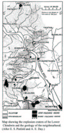
(a) The explosive craters occur on both banks of the Chindwin River around the village of Shwezaye.
(b) The volcanic occurrences on the west bank of the Chindwin River southwards to Shinmadaung.
(c) The volcanic occurrences of the East Monywa Hill Belt.
(d) The Natyindaung mass.
The Explosive Craters occur on both banks of the Chindwin River around the village of Shwezaye.
There exist today seven or eight craters in all, which occur roughly in a straight line on both banks of the Chindwin River about the village of Shwezaye. The line joining these craters bears in a direction of North 33° East, running somewhat obliquely to the normal tectonic direction of the region. The distance between the most northerly and southerly craters, Ywatha and Leshe respectively, is about 13 miles.
The country surrounding these craters on all sides is open plain land floored by alluvium and quartz-pebble-bearing sands of the Irrawaddian age. To the south of Leshe, isolated plateau-like elevations represent sheets of lava, and still farther south, opposite Monywa, are conical-shaped hills composed of rhyolites and other acid igneous rocks.
Ywatha: This crater is 6 ½ miles north-east of The Chindwin at Shwezaye. All that remains is a circular depression, broad and shallow, sunk in soft sands of the uppermost Irrawaddian age. In diameter, the depression, from rim to rim, measures about half a mile and is very shallow when compared with its width, averaging only about 150 feet in depth. The bottom is flat and sandy and is now partially under cultivation. There is no drainage outlet, however, the rim remains intact with precipitous inner slopes, etc.
Twindaung: This crater lies on the east bank of the Chindwin River, about two miles northeast of Shwezaye. Although this is not the largest crater in actual diameter, it is the deepest and most perfectly preserved on account of having a partial rim of basalt on its three sides.
Viewed at a distance from the east, the flat cone of the crater appears as a broad plateau-like elevation, and there is nothing in the topographic outline to suggest the existence of a volcanic vent. Approaching from Budalin, we find the first indications of the proximity of volcanic activity at the village of Kyauko, where, in a stream bed to the west of the village, are horizontal deposits of coarse volcanic ash and lapilli and fragments of lava, with a few quartz pebbles, between layers of fine mud-coloured ash. Although this locality is nearer to the Ywatha crater, which is only 2 miles distant, than to Twindaung, the ashes have undoubtedly been ejected from Twindaung, as there is no mistaking the characteristic lava that forms part of the wall of this crater. In addition to the fragments of lava, there are also individual crystals of black glistening hornblende and brown mica mixed up with the lapilli and ash, evidently comprising part of the ejectamenta from this volcano.
The inner slopes of the crater are everywhere precipitous. Lying some three to four hundred feet below are still dark waters of the crater lake which lap the foot of the sheer crater face to the north and west. According to the local villagers, the depth of the lake in the centre is 74 feet. Sloping down to the water’s edge on the east side is a narrow shelf of volcanic ash upon which the village of Twindaung has been built.
(To be continued).
References: Chhibber, HL, 1934: The Geology of Burma, Macmillan, and Co Limited, St Martin’s Street, London.