Dr Kyaw (Meteorology School)
THE monsoon climate is one of the most prominent features within the global climatic system. The term “monsoon” is derived from the Arabic word ‘mausim’, meaning “season”. Meteorologically, it refers to a system characterized by seasonally reversing winds and the associated rainfall brought by the moisture-laden clouds these winds carry. Unlike daily or weekly weather events such as snowfall or storms, the monsoon is a large-scale, annual, and regular seasonal phenomenon that significantly influences the tropical equatorial belt and the subtropical regions north and south of the equator.
A defining feature of the monsoon is the seasonal reversal of wind direction, which leads to major changes in regional precipitation patterns. For instance, during June, July, and August, the northern hemisphere experiences the moisture-bearing southwesterly monsoon winds from the ocean, resulting in heavy rainfall. Conversely, during the same period, the northwestern part of Australia in the southern hemisphere experiences dry, cool southeasterly winds from the continental interior, leading to a dry season (Figure 1). These changes not only affect agricultural production and water availability across continents but are also integral to global climate cycles known as teleconnections. The monsoon is widely recognized for its profound impact on global food security, energy supply, ecosystems, and the hydrological cycle.
Therefore, the global monsoon system is not merely a regional climatic phenomenon confined to Asia or Africa. Instead, it is a vast planetary-scale atmospheric circulation system that interconnects all the major rainfall-rich regions across the world’s continents. Consequently, a comprehensive understanding of monsoon and wind circulation systems is essential for predicting natural disasters like droughts and floods, managing water resources, and anticipating the impacts of climate change.
Scientific studies of the monsoon began in the late 19th century when the British, needing to forecast rains for agricultural projects in India, tasked scientists with its study. An early record is from the scholar Henry Blanford, who in 1889 first documented the correlation between snow cover on the Himalayan mountains and monsoon rainfall over India. Henry’s innovative scientific methods laid the groundwork for subsequent research on monsoon variability and prediction. Later, in the 1930s, K R Ramanathan elucidated the fundamental physical principles underlying the Indian monsoon.
In Myanmar, a seminal scientific study was Dr Tun Yin’s 1949 paper, “An Analysis of the Aerological and Climatic Characteristics of the Onset of the Monsoon over Burma,” which stands as the first major record of the Myanmar monsoon system. This study remains a significant research paper to this day, as it was one of the earliest attempts to describe regional monsoon processes not only for Myanmar but for Southeast Asia as a whole.
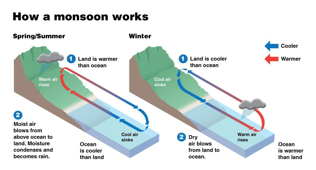
How does the Monsoon form? The monsoon system arises from differential heating between land and ocean surfaces. From May to September, when the northern hemisphere receives direct sunlight, the landmass heats up more rapidly than the adjacent oceans, based on fundamental physical principles. This creates low-pressure systems over the warm land and high-pressure systems over the cooler oceans. The pressure difference between these two systems drives winds, carrying moist maritime air from the southern oceans towards the warmer northern lands. Upon reaching the land, this air rises, forming clouds and resulting in the rainfall we experience as the monsoon. During the winter months (December to February), this process reverses. The land cools faster than the ocean, and winds blow from the land towards the sea, creating dry conditions over continental areas. This mechanism of alternating southwesterly and northeasterly monsoon winds is fundamental to the Southeast Asian monsoon system.
Furthermore, major topographic features like the Himalayan Mountains and the Tibetan Plateau act as barriers, forcing the southerly winds to rise rapidly, which intensifies monsoon rainfall. For example, the high annual rainfall in the Putao and Myitkyina regions of Myanmar is a direct result of this orographic effect.
Although the monsoon occurs seasonally and regularly, its wind strength, rainfall patterns, and amounts are not constant. During the monsoon season, the strength of the monsoon flow fluctuates, alternating between active (strong) and break (weak) periods. For example, during active monsoon periods, central regions of Myanmar may receive less rain, while these same areas often experience heavier rainfall during break periods. These fluctuations are linked to pressure conditions over land and sea, westward-propagating atmospheric wave movements in the Indian Ocean like the Madden-Julian Oscillation (MJO), and global climate drivers such as the El Niño-Southern Oscillation (ENSO) and the Indian Ocean Dipole (IOD). This complex climatic dynamic remains a primary reason why issuing accurate monsoon forecasts continues to be a challenge, despite advances in modern computational climate technology.
Global Monsoon Zones
There are four major monsoon zones in the world:
- The Asian (or South and East Asian) Monsoon Zone: This zone extends across Indonesia, Thailand, Cambodia, Laos, Vietnam, Myanmar, India, Bangladesh, Sri Lanka, China, and Japan.
- The African Monsoon Zone: This occurs in parts of West Africa and the Sahel region south of the Sahara Desert.
- The North American Monsoon Zone: This affects the southwestern United States and parts of Mexico.
- The Australian Monsoon Zone: This occurs in northern Australia.
Among these, the South Asian monsoon system is the largest and most intense. It can be further subdivided based on wind and rainfall patterns into subsystems: the Indian Summer Monsoon (affecting India, Pakistan, Nepal, Bhutan, Bangladesh, and Sri Lanka); the Mainland Indochina Southwest Monsoon (affecting Myanmar, Laos, Thailand, Cambodia, and southwestern China); the East Asian Summer Monsoon (affecting China, Japan, and Korea); and the West North Pacific summer monsoon (affecting Vietnam, the Philippines, and southeastern China).
The South Asian monsoon system is fundamentally based on the complete reversal of wind direction between seasons, primarily the Summer Monsoon and the Winter Monsoon. During the northern hemisphere summer (the rainy season in Myanmar), as the Asian continent heats up, moist winds from the Indian Ocean flow into the resulting low-pressure zone, causing rainfall from May to September. In winter, dry winds blow from the northeast from the high-pressure zone over the continent towards the sea, resulting in significantly less rainfall from October to March.
Although Myanmar falls within the influence of the Mainland Indochina Southwest Monsoon, the country’s diverse geography – its north-south elongation and varied topography of mountains and plains – results in significant regional variations in monsoon rainfall patterns. The Rakhine coastal area is most exposed to the summer monsoon winds. The Rakhine Mountain range also acts as a barrier, forcing moisture-laden clouds to rise and causing extremely heavy rainfall along its western slopes. However, after crossing these mountains, the southwesterly winds become drier, leading to substantially reduced rainfall in central Myanmar. This is why these areas are known as the central dry zone; regions like Magway, Mandalay, and parts of Sagaing frequently experience droughts even during the monsoon season. In contrast, southernmost regions like the Taninthayi Region have a longer rainy season and higher total rainfall because they receive precipitation from both the summer southwesterly and the winter northeasterly monsoon flows.
The global monsoon system is responsible for approximately two-thirds of the annual rainfall in the tropical equatorial and adjacent subtropical regions. Through its direct and indirect influences on regional climates, the monsoon supports agriculture and water resources for about one-third of the world’s population and facilitates trade and food security for nearly three-quarters of humanity. The hydrology of major river basins such as the Ganges-Brahmaputra, Ayeyawady-Mekong, Yangtze, and Niger is almost entirely dependent on monsoon rains. Agricultural systems across Asia, Africa, and Latin America are timed to the monsoon’s onset. Consequently, variations in monsoon strength, which can lead to droughts or floods, frequently threaten global food security.
Recent reports on global climate change indicate that the world’s monsoon system is expected to become more irregular and unstable in the future. While climatologists project that total seasonal rainfall may increase in many parts of South Asia, this increase is not expected to be uniform. Instead, it is likely to be characterized by a higher frequency of heavy rainfall events, longer and more severe dry spells, and changes in the timing of the monsoon’s onset and retreat. These changes directly threaten the food and water security of some of the world’s most densely populated regions, including India, Bangladesh, and China. Therefore, it is recommended that in countries like Myanmar, which have agriculture-based economies, necessary preparations be made by all stakeholders, from farmers to relevant government departments, for the challenges ahead.